|
Home -
Gallery
Geology
Music
Software
Hiking
Links
Sport
What?
Thesis Paleontology Balkan Mineralogy Harz Steno 1 10 20 30 40 50 60 70 80 90 Anh A B C D E F 2 3 4 5 6 7 8 9 E1 E2 E3 E4 E5 |
Page 256 of 401
< > |
I n d e x Anhang VI - 2
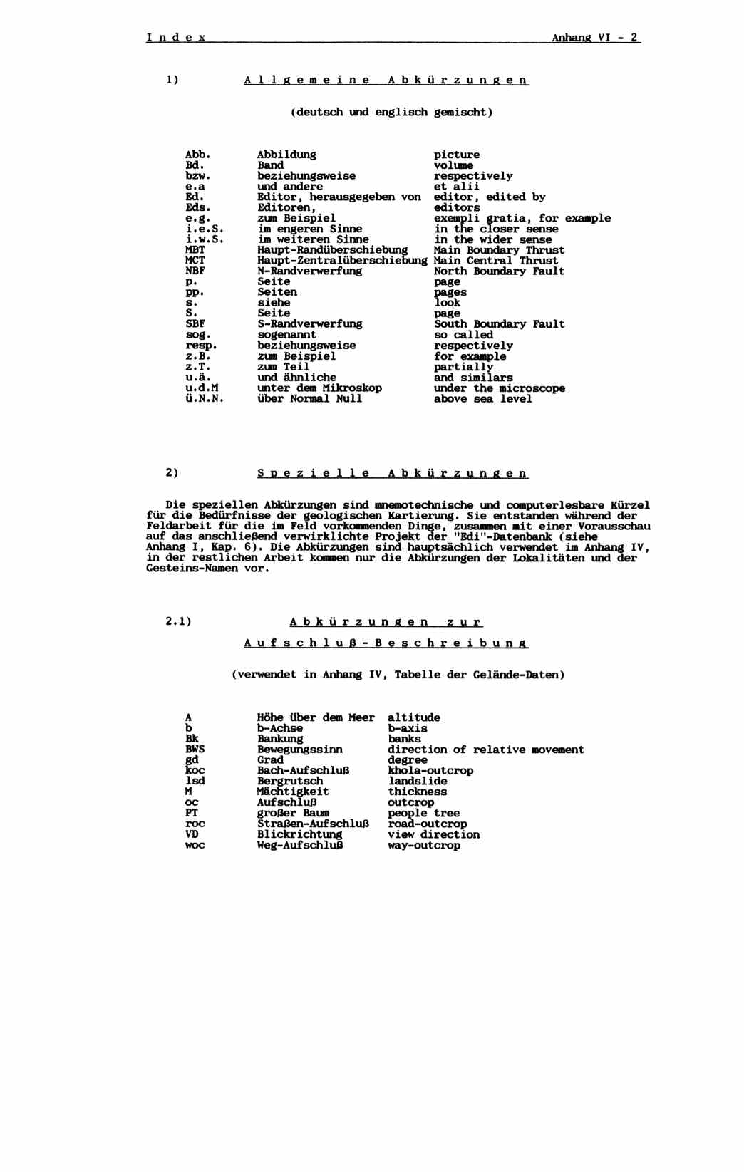
1) A l l g e m e i n e A b k ü r z u n g e n
(deutsch und englisch gemischt)
Abb. Abbildung picture
Bd. Band volume
bzw. beziehungsweise respectively
e.a und andere et alii
Ed. Editor, herausgegeben von editor, edited by
Eds. Editoren, editors
e.g. zum Beispiel exempli gratia, for example
i.e.S. im engeren Sinne in the closer sense
i.w.S. im weiteren Sinne in the wider sense
MBT Haupt-Randüberschiebung Main Boundary Thrust
MCT Haupt-Zentralüberschiebung Main Central Thrust
NBF N-Randverwerfung North Boundary Fault
p. Seite page
pp. Seiten pages
s. siehe look
S. Seite page
SBF S-Randverwerfung South Boundary Fault
sog. sogenannt so called
resp. beziehungsweise respectively
z.B. zum Beispiel for example
z.T. zum Teil partially
u.ä. und ähnliche and similars
u.d.M unter dem Mikroskop under the microscope
ü.N.N. über Normal Null above sea level
2) S p e z i e l l e A b k ü r z u n g e n
Die speziellen Abkürzungen sind mnemotechnische und computerlesbare Kürzel
für die Bedürfnisse der geologischen Kartierung. Sie entstanden während der
Feldarbeit für die im Feld vorkommenden Dinge, zusammen mit einer Vorausschau
auf das anschließend verwirklichte Projekt der "Edi"-Datenbank (siehe
Anhang I, Kap. 6). Die Abkürzungen sind hauptsächlich verwendet im Anhang IV,
in der restlichen Arbeit kommen nur die Abkürzungen der Lokalitäten und der
Gesteins-Namen vor.
2.1) A b k ü r z u n g e n z u r
A u f s c h l u ß - B e s c h r e i b u n g
(verwendet in Anhang IV, Tabelle der Gelände-Daten)
A Höhe über dem Meer altitude
b b-Achse b-axis
Bk Bankung banks
BWS Bewegungssinn direction of relative movement
gd Grad degree
koc Bach-Aufschluß khola-outcrop
lsd Bergrutsch landslide
M Mächtigkeit thickness
oc Aufschluß outcrop
PT großer Baum people tree
roc Straßen-Aufschluß road-outcrop
VD Blickrichtung view direction
woc Weg-Aufschluß way-outcrop
 I n d e x                                                     Appendix VI - 2


    1)           C o m m o n   A b b r e v i a t i o n s

                          (german and english mixed)


      Abb.       Abbildung                  picture
      Bd.        Band                       volume
      bzw.       beziehungsweise            respectively
      e.a        und andere                 et alii
      Ed.        Editor, herausgegeben von  editor, edited by
      Eds.       Editoren,                  editors
      e.g.       zum Beispiel               exempli gratia, for example
      i.e.S.     im engeren Sinne           in the closer sense
      i.w.S.     im weiteren Sinne          in the wider sense
      MBT        Haupt-Randüberschiebung    Main Boundary Thrust
      MCT        Haupt-Zentralüberschiebung Main Central Thrust
      NBF        N-Randverwerfung           North Boundary Fault
      p.         Seite                      page
      pp.        Seiten                     pages
      s.         siehe                      look
      S.         Seite                      page
      SBF        S-Randverwerfung           South Boundary Fault
      sog.       sogenannt                  so called
      resp.      beziehungsweise            respectively
      z.B.       zum Beispiel               for example
      z.T.       zum Teil                   partially
      u.ä.       und ähnliche               and similars
      u.d.M      unter dem Mikroskop        under the microscope
      ü.N.N.     über Normal Null           above sea level


    2)               S p e c i a l   A b b r e v i a t i o n s


    The special abbreviations are mnemotechnical and computer readable
 shortcuts for the purposes of the geological mapping. They were created
 during the field work for the actual occurring things, with the following
 project of the "Edit" database in mind (see Appendix I, Chapter 6). The
 abbreviations are mainly used in Appendix IV, in the rest of the work
 only the abbreviations of the localities and the rock types are used.


    2.1)               A b b r e v i a t i o n s   f o r   t h e

                       O u t c r o p   d e s c r i p t i o n s

                   (used in Appendix IV, Table of the Field Datas)


         A          Höhe über dem Meer  altitude
         b          b-Achse             b-axis
         Bk         Bankung             banks
         BWS        Bewegungssinn       direction of relative movement
         gd         Grad                degree
         koc        Bach-Aufschluß      khola-outcrop
         lsd        Bergrutsch          landslide
         M          Mächtigkeit         thickness
         oc         Aufschluß           outcrop
         PT         großer Baum         people tree
         roc        Straßen-Aufschluß   road-outcrop
         VD         Blickrichtung       view direction
         woc        Weg-Aufschluß       way-outcrop
|
.